
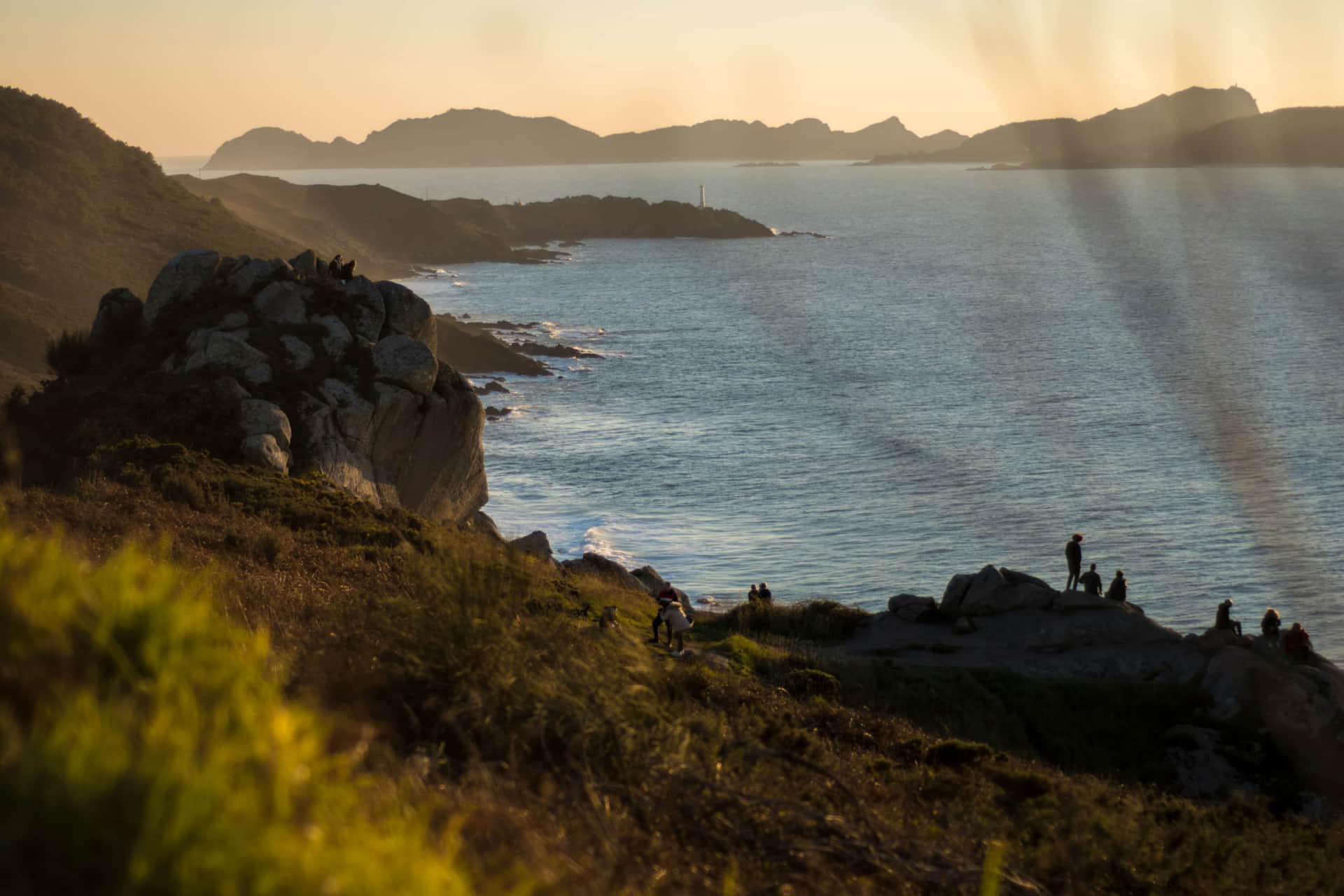
The Costa de la Vela is the Atlantic-facing edge of the Morrazo Peninsula — rugged granite cliffs, coastal pine and eucalyptus forest, four remarkable beaches, three working lighthouses, and one of the oldest Celtic sanctuaries on the Iberian Peninsula. It begins 20 minutes from Cangas by car. This is the guide.
🗺️ At a Glance
| Distance (one way) | ~12 km (Nerga to Cabo Home) |
| Full return | ~24 km |
| Difficulty | Moderate |
| Time (full return) | 7–8 hours including stops |
| Shorter option | Cabo Home lighthouse circuit from the car park: 3–4 km, easy |
| Start point | Playa de Nerga |
| End point | Cabo Home (three lighthouses) |
| Footwear | Trainers (dry) · Boots recommended Oct–Apr |
| From Cangas | 20 minutes by car or local bus |
| Best time | Year-round · October is exceptional |
| Waymarking | Yellow markers · also signed as Senda Costeira |
📍 What Is the Costa de la Vela?
The Costa de la Vela — also written Costa da Vela in Galician, meaning the Sailing Coast — runs along the western edge of the Morrazo Peninsula between the Ría de Vigo to the south and the small Ría de Aldán to the north. It covers a protected strip of coastline of more than 10 km, with a total surface area of around 1,385 hectares, of which over 1,000 are marine waters.
It is a Zona Especial de Conservación (ZEC) within the European Natura 2000 network, and it is contiguous with the Atlantic Islands of Galicia National Park — meaning the Islas Cíes, visible just 2.5km offshore from Cabo Home, lie within the same protected natural system.
The landscape is not uniform. On the Ría de Vigo side, the coast is sheltered, the beaches are calm, and the dune systems between Nerga, Viñó, and Barra form the largest dune complex in the province of Pontevedra after A Lanzada. As the path rounds the headland toward Cabo Home, the character shifts entirely: the ría drops behind you, the open Atlantic takes over, and the granite cliffs above Donón reach over 150 metres above the sea. These are two completely different coastlines connected by a single trail.
Getting There
🚗 Playa de Nerga is 20 minutes from Cangas do Morrazo by car — follow the road toward O Hío and Donón, taking the first turnoff for Nerga
🚌 Local buses run from Cangas to Nerga in summer · check Monbus schedules in autumn and winter as frequency drops
🏡 Staying at Faros da Ría in Nerga? The trail begins at the southern end of Playa de Nerga, directly outside the apartments
🥾 The Route: Nerga to Cabo Home
The path from Playa de Nerga to Cabo Home is approximately 12km one way. It is well-marked with yellow waymarkers and signed at junctions as Senda Costeira. The route alternates between clifftop exposure with open views across the Rías Baixas and the Islas Cíes, and sheltered forest sections through pine and eucalyptus that smell extraordinary after rain. Elevation gain is modest overall — steep at the clifftop viewpoints and in the climbs between beaches, gentle along the shore and through forest.
Most walkers take 3.5–4 hours each way at a comfortable pace, with stops for swimming and views. The full 24km return requires reasonable fitness and a full day. There is no circular route from Nerga that avoids retracing your steps; the circular options start from Donón or Cabo Home instead.
The Beach Sequence
The walk passes through a natural sequence of beaches, moving from sheltered ría water to open Atlantic:
Playa de Nerga
Start · 700m · Blue Flag · car access
Praia de Viñó
300m · sheltered · nudist · pedestrian only
Praia da Barra
750m · Blue Flag · nudist · dunes
Praia de Melide
250m · wild · pine-backed · Cíes views
Cabo Home
End · three lighthouses · panoramic
Playa de Nerga is the starting point — 700 metres of fine white sand with a Blue Flag, calm and sheltered by the geometry of the Ría de Vigo. Known locally as Folla de Nerga, recognisable by a large rock sitting in the middle of the sand. Small traditional fishing boats (gamelas) are often drawn up at the northern end. At the southern end of the beach, a track climbs through the pine dunes toward Praia de Viñó.
Praia de Viñó — the smallest and most sheltered of the three ría-side beaches, known traditionally as Praia de Area Meán. Pedestrian access only; 300 metres of sand backed by pine dunes. Mixed nudism is common here. The name (Viñó = wine) comes from the historical practice of cultivating vines directly in the sand.
Praia da Barra — 750 metres of fine white sand, considered the finest nudist beach in Galicia. The dune system is protected within the Natura 2000 network for its ecological value — mobile dunes shifting seasonally, pine forest reaching almost to the water's edge. At the end of Barra, cross the small stream and take the ascending path through pine then eucalyptus to Punta Subrido. This 200-metre climb through forest is the steepest section of the entire walk.
Along the path between Barra and the lighthouse area, a short detour leads to the ruins of a Roman-era salazón — a salt fish factory that exported sardines across the Empire. Ruins of a whale processing factory are also visible nearby. History is everywhere on this coast, if you look for it.
Praia de Melide — reached via a descent through pine forest, 5 minutes from the Cabo Home car park. 250 metres of fine white sand, Blue Flag, almost entirely isolated, with the Islas Cíes directly in front. Open Atlantic water — colder than the ría beaches, but extraordinary on a calm day.
The Shorter Route from Donón
If the full 24km return is too long, start from the Donón/Caracola car park and walk the lighthouse circuit plus Melide — roughly 3–4km, easy, suitable for all ages. The car park is free and large, reached via a dirt track from the Caracola sculpture viewpoint in Donón (suitable for all vehicles). This is also the starting point for Monte do Facho.
🔦 The Three Lighthouses of Cabo Home
Cabo Home is defined by three lighthouses packed within barely 2km of each other — each marking a different point of the cape and together guiding vessels through the entrance to the Ría de Vigo. All three are operational, accessible on foot, and each has its own distinct character.
Faro de Punta Subrido
White cylindrical tower. The first you reach from Barra. From here the views back over Nerga, Viñó, and Barra are exceptional. Regulates the southern entrance to the Ría de Vigo for vessels arriving from the Atlantic.
Faro de Punta Robaleira
Red cylindrical tower, built 1918. Low and wide, only 6m tall, 27m above sea level, light carries 12km. At its base: a stone cross for Pepe Ruiz, a local fisherman dragged onto the rocks by the current when his engine failed.
Faro de Cabo Home
First lit 1865. White with blue at the base, 17–18m tall, three floors — one of the tallest on the Galician coast. A foghorn was added later for the persistent sea mists. The Cíes are just 2.5km from its base. An anonymous artist carved a cheetah into the rocks below.
Local legend explains the jagged rocks below the Cabo Home cliffs: they are the petrified remains of a sea monster defeated by a warrior named Oridón, after many attempts and much struggle. The creature's spines petrified as it sank into the sea. The warning from local fishermen: be careful not to wake it.
The sunset from Cabo Home — the sky behind the Cíes silhouette igniting to the west — is among the finest in all of Galicia. Plan your start time to arrive here in the late afternoon.
🏛️ Monte do Facho — The Oldest Sanctuary in Galicia
The single most significant thing most visitors to the Costa de la Vela walk past without knowing is Monte do Facho — a 160-metre summit above Donón containing one of the most important archaeological sites in the entire northwest of the Iberian Peninsula.
The name encodes the history: facho is Galician for torch or beacon; donón derives from a Celtic word meaning stone enclosure. The site has been occupied since the Bronze Age (9th century BC) — as an open settlement, then a Celtic hillfort, then a Roman pilgrimage sanctuary, then a military watchtower. More than 2,000 years of continuous occupation on one summit.
In its Celtic period (from around the 4th century BC), Monte do Facho became the settlement of Beróbriga — a hillfort with around 50 circular stone houses, two defensive walls, and a stone-paved road still partially visible. Its position gave total visual command over the entrance to both the Ría de Vigo and the Ría de Pontevedra, with the Cíes and Ons directly offshore.
What makes the site exceptional is what came in the Roman period. From the 2nd–4th century AD, the ruins were converted into a pilgrimage sanctuary dedicated to the god Berobreo — a deity of healing and the Otherworld, previously entirely unknown to historians. Pilgrims came from across the northwest of the peninsula to place stone altars at the summit and pray for health.
Excavations beginning in 2003 (a joint Spanish-German team) revealed 174 votive stone altars — the largest collection of votive altars found anywhere on the Iberian Peninsula. Every altar carries the same Latin inscription: DEO LARI BEROBREO ARAM POSUIT PRO SALUTE — "To the god Lar Berobreo, this altar was set up for health." Unfinished altars were also found nearby, suggesting a workshop manufacturing offerings for arriving pilgrims. The altars are now in the Museo Arqueológico de Vigo (Pazo de Quiñones de León, Castrelos — free entry).
At the summit, a 17th-century circular granite watchtower — the garita — was built from the ruins of the Roman sanctuary, used to watch for Turkish pirate raids on the Galician coast. It is still intact. Wooden walkways allow visitors to walk among the excavated castro remains. The views from the top — the entire Costa de la Vela, the Cíes at 2.5km, Ons to the north, Finisterre on clear days — are arguably the finest on this coast.
Visiting Monte do Facho
🚶 30 minutes on foot from the Caracola sculpture in Donón · follow the dirt track, then the signed narrow path uphill to the left
🪨 Wooden walkways allow you to walk among the excavated castro without disturbing the site
🏺 The 174 altars are in the Museo Arqueológico de Vigo, Pazo de Quiñones de León — free entry
🌅 The summit offers arguably the finest viewpoint on the entire Costa de la Vela
⛪ The Cruceiro do Hío — Galicia's Greatest Stone Cross
On the road between Cangas and Nerga, the village of O Hío contains one of the most remarkable pieces of popular art in Galicia: the Cruceiro do Hío, considered the finest cruceiro (stone wayside cross) in the region — described by those who have catalogued Galicia's 12,000 such monuments as the peak of Galician popular art.
Carved in 1872, attributed to the master stonemasons José Cerviño García and Ignacio Cerviño Quinteiro, the cruceiro is exceptional for one reason: almost the entire monument was cut from a single block of granite. Over 30 figures are carved across its surface, narrating the story of Christianity from Adam and Eve at the base to the Descent from the Cross as the central scene — with the Virgin of Carmen, souls in Purgatory, and the Virgin crushing the dragon arranged below. The iconography is Baroque in density; the execution in granite is astonishing.
It stands in the square of the Church of San Andrés in O Hío, alongside a 12th-century Romanesque church façade and a handsome 17th–18th century rectory with gardens, hórreo (granary), and dovecot. The views from the church grounds over the Ría de Aldán are unexpected and beautiful.
On the 16th of August every year, the traditional Danza de San Roque — the Dance of the Pilgrims, a tradition dating to the 14th century — is performed in front of the cruceiro by twenty male dancers in pilgrims' costume. The Cruceiro do Hío is 5 minutes from the Nerga turn-off and easily combined with the Costa de la Vela walk on the same day.
📅 Best Time to Walk
Summer · June–September
Warm enough to swim at all four beaches. Nerga and Barra busy in July–August; Melide is always quieter. The section beyond Barra toward Cabo Home is never crowded even at peak season. Arrive early at Nerga for parking.
Autumn · October–November
The finest time for the walk. Empty trail, dramatic Atlantic light, genuinely wild clifftop sections in autumn swell. The eucalyptus and pine forest smells strongest after rain. October is the best single month on the Galician coast for walking.
Winter · December–February
Full Atlantic force on the Cabo Home headland. The lighthouse sections feel earned. The beaches are completely empty. Dress for wind, not just cold.
Spring · March–May
Wildflowers on the clifftop paths, the sea warming, very few people. The Cíes ferry begins running daily from Easter — a combined Costa de la Vela walk and Cíes day is a natural two-day pairing for a stay in Nerga.
🎒 What to Bring
After a day on the Costa de la Vela, returning to Cangas feels like the natural conclusion — cold Albariño on the terrace, the lights of Vigo coming on across the Ría de Vigo, legs doing what tired legs do. The Costa de la Vela and Cangas belong to each other. One gives the day; the other gives you somewhere to put it down properly.
Frequently Asked Questions
How difficult is the Costa de la Vela walk?
The full Nerga to Cabo Home walk (12km one way, 24km return) is moderate — not technical, but requires reasonable fitness and a full day. The steepest section is the 200-metre climb from Praia da Barra to Punta Subrido through eucalyptus forest. Trainers work in dry conditions; boots better from October to April.
The shorter Cabo Home lighthouse circuit from the Donón car park is 3–4km, easy, and suitable for all ages.
Can you see the Islas Cíes from the Costa de la Vela?
Yes — clearly. From Cabo Home, the Cíes are just 2.5km offshore and visible in detail on any clear day. Praia de Melide sits directly in front of them. From the clifftop near Punta Subrido, the view back over Nerga, Viñó, and Barra with the Cíes on the horizon is one of the finest on the Galician coast.
→ Read our complete guide to visiting the Islas Cíes from Cangas
What beaches are on the Costa de la Vela?
From north to south: Playa de Nerga (700m, Blue Flag, sheltered, car access), Praia de Viñó (300m, sheltered, nudist, pedestrian only), Praia da Barra (750m, Blue Flag, best nudist beach in Galicia, dune system), and Praia de Melide (250m, wild, pine-backed, Blue Flag, open Atlantic, direct Cíes views — pedestrian access from the Cabo Home car park).
How many lighthouses are at Cabo Home?
Three, within 2km of each other: Faro de Punta Subrido (white, first reached from Barra), Faro de Punta Robaleira (red, built 1918, stone cross at its base for a fisherman lost on these rocks), and Faro de Cabo Home (first lit 1865, one of the tallest in Galicia, foghorn added later for sea mist). All three are operational and accessible on foot.
What is Monte do Facho?
Monte do Facho is a 160-metre summit above Donón containing a Celtic hillfort (the castro of Beróbriga, 4th century BC), later converted into a Galician-Roman pilgrimage sanctuary dedicated to the god Berobreo. Excavations found 174 votive stone altars — the largest collection on the Iberian Peninsula. A 17th-century granite watchtower built against pirate raids still stands at the top. 30 minutes on foot from the Caracola. The altars are in the Museo Arqueológico de Vigo (free entry).
What is the Cruceiro do Hío?
The finest cruceiro (stone wayside cross) in Galicia, in the village of O Hío on the road between Cangas and Nerga. Carved in 1872 almost entirely from a single block of granite, with over 30 figures narrating the story of Christianity from Adam and Eve to the Descent from the Cross. Easily combined with the Costa de la Vela walk — it's 5 minutes from the Nerga turn-off.
What is the best time to walk the Costa de la Vela?
Year-round, but October is the finest single month — empty trail, dramatic Atlantic light, no crowds, and the eucalyptus forest at its most aromatic after autumn rain. Plan to arrive at Cabo Home in the late afternoon for the sunset over the Cíes.
How far is Nerga from Cangas?
20 minutes from Cangas do Morrazo by car or local bus. The Faros da Ría holiday apartments are in Nerga, directly at the start of the Costa de la Vela trail — the walk begins at the southern end of the beach.
Is the Costa de la Vela walk suitable for children?
The full 24km return is too long for most children. The shorter option from the Cabo Home car park — lighthouse triangle plus Praia de Melide — is 3–4km and manageable for most ages. Playa de Nerga is calm and safe for children of all ages.
Can you drive to Cabo Home instead of walking?
Yes. A dirt track from the Caracola sculpture viewpoint in Donón leads to a large free car park near the lighthouse area — accessible to all vehicles. From the car park, all three lighthouses and Praia de Melide are within easy walking distance. This is also the starting point for Monte do Facho.